While Megalopolis is located in the Eastern United States, The Dalles is far from a megalopolis, both distance and theme-wise. In the Beaver state, Portland, Oregon would have to be the most urbanized area. This is the beginning of the introducing the term PORT CITY.
84 Miles west of The Dalles, running adjacent to the Oregon-Washing border, you'll find Portland, the closest main city (Google map).
Within the last ten years, Portland has indeed grown. The 2010 Census tells us that its the 29th most populous city in the United States (pdf source - Census Profile). As for Wasco County, the population in 2000 was at 23K and has gone up to about 25K.
Although the harbor is another approximate 70 miles more west, Portland benefits its goods for the rest of Oregon to enjoy. It's got the Pacific Ocean to the west, and the Columbia River to the north.
The "megalopolis" stage in a city such as Portland is way at its beginning. Efforts to maintain the city sustainable, is taking steps forward into becoming a busy, urbanized city without the environmental hazards of pollution, traffic, et cetera; something that Eastern US's Megalopolis has endured through since it grew.
Tuesday, October 11, 2011

People - From Natives to Settlers To Now (with maps).

 Since European settlers started off in Eastern United States in the late 1700's, it took awhile for them to make their settlement (1850-1890). It was in 1890 when the US Census Bureau stated that there was "no more frontier" for the settlers, since at this point they reached the west coast. Oregon state was one of those states.
 A more present map and explanation of population: in 2006, the Census Bureau calculated people per square mile. It seems like Portland, The Dalles neighboring city, is occupying the largest density of people. Looks like The Dalles occupies 7-80 people per square mile throughout.
Oregon's region where there the densest population today is due to its location...location, location, location. The Dalles and Portland are close to the Pacific Ocean, and Portland is considered a "port city" as the second map show.. Its advantage to its situation towards the coast will be explained in later blog entries. Stay tuned :)
Tuesday, September 20, 2011
The Dalles - Four Seasons
Since we were on the subject of climate in the last entry, I thought we can take a break from the charts and graphs with this pretty well-put video that someone compiled of landscape images of The Dalles. Many of these images of The Dalles are as I remembered it: the train, the dam, the large conifer trees at the parks, there's even images of those cold snowy winters. Play some music on your iTunes and check it out!
Climate
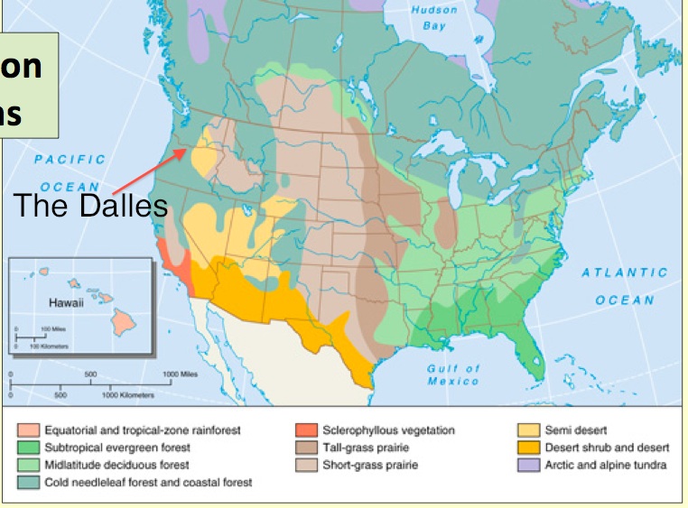

Glad I was able to toy with simple .pdf edits! Here we go....
Looks like The Dalles is dominated by cold needleleaf forrest & coastal forest. Although, just a glance to its left is semi-desert. It explains the fact that there's so many pine trees, its snowy winters that it shares with Washington's northwest.
Here's a chart of their annual averages courtesy of usclimatedata.com
 LOTS of precipitation during the winter. While my family in The Dalles does claim that it begins to rain plenty during the month of November, it increases during December and January. These past few years, strong snow blizzards and storms have occurred during the winter, a head-scratcher in terms of non-average weather occurrences and possible climate change.
 Sunday, September 11, 2011
Physiographic Cusp
 |
| Courtesy of Regional Landscapes of The U.S. & Canada, Ch.2, pg 19. |
Physio Region
Since the Dalles is technically on the Columbia Basin, that very basin shares two physiographic regions: Pacific Mountains & Valleys (west) & Intermontaine Basins & Plateaus (east). Judging from just looking at the map, it is definitely hard to pinpoint what physiographic region The Dalles is a part of.
I had to bump my google searching up a notch in order to get a clearer answer.
 |
| Thank you OSU (source). |
It is a narrow province that runs north-south. It neighbors the Cascade Mountains as well. Physioregion-wise, The Dalles leans towards the Pacific Mountain & Valley region. According to this OSU description of Oregon's provinces, there are foothills and mountain slopes running east-west, coming from basalt cliff canyons from the Cascades, draining into Deschutes and Columbia rivers.
Soils
The eastern slopes of Mount Hood & the Cascades have influenced the soil types in The Dalles: aeolian silts, volcanic ash, andesitic, basaltic, sedimentary colluviums, glacial outwash (OSU source). According to Chapter 2's Regional Landscapes of The U.S. & Canada, this map demonstrates the soil territories throughout the states.

Mollisols are the soil type territory for North-central The Dalles. According to the chapter, mollisols are one of the most fertile soils there is. The texture is thick, dark, and very rich in nutrients. This explains very well the cultivation of cherries and peaches in the fields of The Dalles!
I'm quite intrigued over the fact that The Dalles neighbors different elements of the region next to theirs. The fact that it runs north-south, shares different geographic territories, Cascades in the south, Columbia grassland basin to the north. I'm excited to learn more about how this little piece of "regional cusp", as I have labeled, transitions within those 100 miles.

Mollisols are the soil type territory for North-central The Dalles. According to the chapter, mollisols are one of the most fertile soils there is. The texture is thick, dark, and very rich in nutrients. This explains very well the cultivation of cherries and peaches in the fields of The Dalles!
I'm quite intrigued over the fact that The Dalles neighbors different elements of the region next to theirs. The fact that it runs north-south, shares different geographic territories, Cascades in the south, Columbia grassland basin to the north. I'm excited to learn more about how this little piece of "regional cusp", as I have labeled, transitions within those 100 miles.
Next post: Climate & Vegetation.
[Research curiosity alert: Deschutes, Columbia River systems, cherries!]
Tuesday, September 6, 2011
Region of The Dalles

The Dalles is situated on the North Pacific Coast Region.
This map of the state demonstrates the 7 regions Oregon state is made up of. The Dalles is right on the Columbia Gorge region. The boundaries within the Eastern Oregon region is actually under the Empty Interior region, which is shared by parts of Central Oregon, a slice of eastern Washington State, Idaho, & Montana.
Agriculture is what moves the city, as sweet cherries are their number one agricultural product. Since I spent a few summers there as a child, I was no stranger to the cherries phenomena. My uncle happened to work in the cherry fields, and he'd bring home buckets of sweet cherries every day.
The City of The Dalles website lists over 13,000 people as their current population.Since it is so close to the Washington border, it serves as a trading area of 70,000 people between both states. Year-round recreational activities pulls in people from many parts of the Pacific North West. (source)
Picture courtesy of retirenet.com
Tuesday, August 30, 2011
Welcome To The Dalles

You are now entering The Dalles, a small town in Northern Oregon where Washington State is within hand's reach.
Subscribe to:
Posts (Atom)